Research Update on Geomembranes at Tailings Storage Facilities
August 08, 2017
Over the past three years, KCB has been expanding our implementation of drone and remote sensing technologies to improve project deliverables, help clients and stakeholders visualize sites, and identify potential site issues from different vantage points. Currently, we are operating drones for a variety of projects and clients, from railways to roads and highways, to hydroelectric facilities.
Since 2018 KCB has been using two drones, the DJI Phantom 4 Pro, and the DJI Mavic Pro with experienced and licensed drone operators. Both drones feature 20 megapixel cameras capable of capturing 4k video with 30 minutes of flight time on a single battery.


DJI Drones – Phantom 4 Pro (Left) Mavic Pro (Right)
These drones combined with KCB’s suite of photogrammetry software, ArcGIS Drone2Map, allow us to process the data and deliver the output to clients efficiently through software that is widely used in the industry without the need to convert file types. This technology allows the creation of both 2D and 3D models of project sites which can be georeferenced using the drones' built-in GPS, or with Ground Control Points (GCPs) for improved accuracy.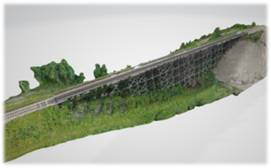
3D Photogrammetry Model of Railway Bridge
KCB has also implemented photogrammetry rock slope mapping using 3DM Analyst software with terrestrial and aerial drone photos. This has decreased KCB’s time spent in the field and allowed us to remotely collect information of areas which might otherwise be unsafe to map. Combining this tool with traditional field mapping techniques allows for the collection of much larger data sets which can be analyzed by a variety of geotechnical software.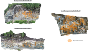

Rock face mapping using 3DM Analyst
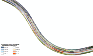
Volumetric Change Detection for Linear Infrastructure Construction
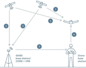
RTK Communication Lines
Our industry’s new duty of care extends to preventing the spread of infection to others while serving our clients. Our initial reaction was for everyone to work from home, but we soon realized it wasn’t always practical or efficient. Some employees adapted to their home situation with ease, but many didn’t have enough space or connectivity to work from home effectively. It was also difficult for new employees to make new acquaintances, and for many of our projects, we still had to travel and work in the field.
Almost immediately, we started to plan for the safe return to our workplaces. We carefully assessed our offices and field sites, and had to re-think project delivery to our clients, starting with do we absolutely need to travel and how can we do this differently? We prepared plans for travelling safely, supplied new PPE, developed new communication protocols, and planned emergency response measures if someone became infected.
We dedicated lots of time to develop and communicate safety plans with our employees and clients. During the pandemic, we must not underestimate how long it takes to meet our new duty of care.
The New WorkplaceReturning to our workplaces was the first (and perhaps easier) step. Once back, we realized that our collective daily habits had to change, and that it could potentially last for years rather than months. The new workplace is one of physical distancing and sanitization, and continual reinforcement of the rules. We now speak a new language - one that describes testing methods, infection rates and the difference between quarantine and self-isolation. And as we move differently around the office, we’ve learned a new dance of maneuvers around the water cooler!
Although the engineering consulting industry has always had a strong culture of safety, we have never faced a pandemic such as this. Post-pandemic safety cultures must now include new levels of communication, hygiene and health monitoring; and the post-pandemic C-suite must be bolstered by corporate medical professionals or a healthcare team.
The COVID-19 pandemic has reinforced the notion that our industry is founded on people. It may seem obvious, but we often focus too hard on the projects and lose sight of the clients, contractors, engineers and geoscientists that make the projects work. Our reputation for integrity and passion for our craft, will serve us well as we adapt to these new challenges.

KCB regularly uses a light-weight drone to collect high-quality images and videos from elevated platforms for routine embankment construction monitoring activities at the Hidden Valley mine site in Papua New Guinea. The drone, which belongs to our client, Harmony subsidiary Morobe Consolidated Goldfields Limited, provides a number of benefits to KCB field staff working in remote locations of the mine site, such as the Hidden Valley tailings storage facility (TSF), including:
KCB also uses the drone field data to integrate with LiDAR and survey data collected by a survey drone. The survey drone is a larger unit than the equipment used by KCB for routine monitoring because it is required to carry a larger payload at altitudes of 2,000-2,500 metres above sea-level and be able to collect field data for longer periods of time.
KCB has experienced a number of challenges using the small drone at the Hidden Valley mine site, some of them unexpected:
Tailings dam construction has evolved and improved over the past several decades. Klohn Crippen Berger (and its predecessor companies) helped to revolutionize the design of modern tailings storage facilities 50 years ago, and our engineering approach continues to be the hallmark of international practice. Today, we provide solutions for some of the largest, technically challenging tailings storage facilities in the world.
In the early days, tailings were simply disposed of in local rivers and streams. It was only in the 1960s when the first tailings dams were built. Today, other technologies such as filtered tailings and co-disposal are being used around the world. Here is a timeline of tailings dam construction, as well as a brief overview of the three main types of tailings dam designs.
Historically, the only option for tailings storage was to deal with a tailings slurry. Tailings were disposed of in the most convenient manner, such as in rivers and streams. By about 1930, this type of tailings disposal was stopped in the western world, creating the first benchmark regulations on mine waste management. In a few areas of the world, tailings are still disposed of in waterways, especially areas that have high rainfall and steep, unstable terrain. However, this method of disposal is no longer common practice, mainly because of environmental concerns.
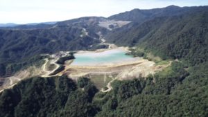
Up until the 1960s, tailings dam designs either used the upstream dam construction method or conventional water storage dam designs to contain the tailings. An early photo of upstream dam construction is shown in Figure 1.

Cycloning of tailings was developed in the 1960s and continues to be a major component of tailings dams (McLeod and Bjelkevik, 2017). In 1962, cycloned tailings for dam construction was first adopted on the Zambian Copperbelt, with the construction of the Lubengele Dam.
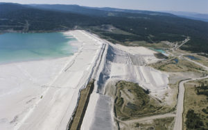
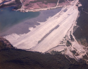
In the mid 1960s, Earle Klohn, one of the founders of Klohn Crippen Berger, pioneered the design of centerline cycloned sand dams (see Figure 2 below). This was one of the first engineered tailings dam designs in the world. The design was based on the sound principles of soil mechanics and still, to this day, meets seismic criteria for high dams. The Brenda Mine tailings dam in British Columbia is the first centerline cycloned sand dam in the world (see Figure 3 below).
In an almost prescient quotation, Earle Klohn stated the following in an address to the University of Missouri in 1977:
“There would appear to be no doubt but that in the very near future, all tailings dams will be designed and constructed using sound engineering principles based on conventional water storage dam design technology. Moreover, the design and construction of tailings dams will be closely controlled by both state and federal agencies. The added cost associated with satisfying such regulations, must, in the future, be considered as part of the cost of developing the mine.” (McLeod et al. 2015)
During the 1970s, the number of tailings dams in Canada and worldwide started to significantly increase with the expansion of the mining industry. The heights of tailings dams started to exceed 300 m.
The upstream method of tailings dam construction started to be replaced by the centerline and downstream methods “using cyclone sand embankments, blanketed upstream by spigotted slimes” (Klohn & Maartman, 1972). Downstream and centerline methods resulted in safer tailings dams, especially in seismically active regions. In addition, the mining industry and government regulators were becoming more aware of the need for better and safer tailings dams “to meet basic requirements of safety and pollution control” (Klohn & Maartman, 1972).
The use of filtered tailings became more popular in the 1980s. However, significant equipment and operational costs (mainly power consumption) made the filtering of tailings not feasible for most operations (McLeod and Bjelkevik, 2017). With improvements in the efficiency of filtering equipment, the interest towards tailings filtering has increased in recent years.
Thickening has been used to improve water recovery from tailings streams since the mid-1990s. Thickening the tailings slurry as part of the process plant operation using conventional thickeners has become a common practice over the last few decades (McLeod and Bjelkevik, 2017).
The recent practice of sulphide separation with a flotation circuit in the process plant can produce a tailings product with a low acid rock drainage potential (McLeod and Bjelkevik, 2017). Co-disposal, the placement of acidic mine waste rock with tailings, has gained increased acceptance. Integration of tailings with mine waste rock is important and can be used to reduce costs and risks. Other technologies reduce evaporation losses, for example the use of cells in arid climates to limit the evaporation losses from the wetted beach surfaces (McLeod and Bjelkevik, 2017).
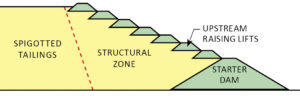
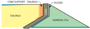
Upstream construction involves a “starter” dyke which is raised as the pond is filled. The tailings are discharged by spigotting from the top of the starter dyke.
Earle Klohn (1971) mentioned that engineering knowledge and experience must be blended with mining operators’ knowledge to develop economically feasible solutions. “One of the first results of blending of knowledge was the development of the downstream method of dam building” (Klohn, 1971).
A downstream dam is built with sand fill, usually separated from tailings by cycloning. No tailings are mixed with the sand dam, as the dam is built in the downstream direction.
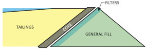
Centerline dams are a variation of the downstream dam. In this case the central core zone is supported by the tailings and a localized zone of fill is placed on top of the tailings (McLeod and Bjelkevik, 2017).
Klohn, E.J. 1971. “Design and Construction of Tailings Dams”. Presented at the Annual Western Meeting of the CIM, October 1971, Vancouver BC, CIM Transactions volume LXXV, pp. 50-66, 1972
Klohn & Maartman, 1972. “Construction of Sound Tailings Dams by Cycloning and Spigotting,” in Proceedings of the 1st International Tailing Symposium, October 31-November 3, 1972. Tucson, Arizona.
McLeod, H.N., B.D. Watts and H.D. Plewes. 2015. "Best Practices in Tailings Dam Design," in CIM 2015 Convention, Montreal, QC, May 10-13.
Leonoff, C. 1994. A Dedicated Team: Klohn Leonoff Consulting Engineers 1951-1991. Richmond, BC: Klohn Leonoff Ltd.
McLeod, H. and A. Bjelkevik. 2017. "Tailings Dam Design: Technology Update (ICOLD Bulletin)," in Proceedings of the 85th Annual Meeting of International Commission on Large Dams, July 3-7, 2017. Prague, Czech Republic: Czech National Committee on Large Dams.
Tailings.info http://www.tailings.info/basics/history.htm. Jon Engels
Wikipedia. https://en.wikipedia.org/wiki/Tailings
An initiative to draft a Global Tailings Standard wrapped up its public consultation phase recently and Klohn Crippen Berger was among the stakeholders to submit feedback to the draft guidelines.
The standards are being developed by the Global Tailings Review, a joint effort between the International Council on Mining & Metals (ICMM), the UN Environment Programme, and Principles for Responsible Investment.
The Review was convened following the failure of the tailings storage facility at the Córrego do Feijão iron ore mine, near Brumadinho, Brazil, in January 2019. It aims to establish a standard for the construction, operation, and management of tailings facilities worldwide.
Specifically, the Review has three main goals for its final Standard:
The draft Standard is divided into six subject areas, each with a set of requirements. As described by the ICMM, the subject areas are as follows:
The Review will evaluate current best practices in the mining industry and, in addition to evidence and lessons learned from Brumadinho, it will consider findings from tailings facility failures at Mariana in 2015, and Mount Polley in 2014.
The Review held in-country consultations throughout November and December in Kazakhstan, China, Chile, Ghana, South Africa, and Australia.
The final Standard and accompanying recommendations — supporting the Standard and outlining how it is to be implemented — are to be published later in 2020. Along with the Standard, the Global Tailings Review will publish a consultation report reflecting the feedback, key themes, and ideas submitted by different stakeholder groups.
Following publication of the final Standard, all 27 ICMM member companies are expected to commit to its implementation. Thirty-six exploration and mining industry associations and commodity groups also belong to the ICMM.
Download the draft Global Tailings Standard.
Watch a webinar on the technical and environmental/social governance aspects of the draft standard.British Columbia’s hydroelectric dams have contributed to reducing the impacts of a shifting climate for more than 100 years. In 2019, hydropower continues to be one of the best ways to meet the challenge of society’s demand for energy in a low carbon, climate-protecting business environment.
Canada’s 2030 target to reduce greenhouse gas (GHG) emissions to 30% below its 2005 level of 732 megatonnes of carbon dioxide equivalent (Mt CO2 eq) (1) is ambitious, but here in B.C. – the fourth largest producer of electricity in Canada(2) – we believe it can be done.
Achieving the target requires, among other things, phasing out coal-fired power plants across the country and switching to a mix of renewable electricity sources such as hydropower, wind, solar and biomass generation. In B.C., where we’ve been drawing upon renewable energy sources for more than a century, we’re ahead of the game. In 2019, 90 percent of our electricity comes from hydropower, generating close to 16,000 megawatts annually.
B.C.’s GHG emissions in 2017 were approximately 62 Mt CO2 eq, or 8 percent of Canada’s total emissions,(3) accounting for 13 percent of the population. The future of hydropower in B.C. continues to be very promising; the province will be a major player in helping Canada to meet its 2030 target.
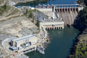
The province’s primary producer of electricity, BC Hydro, generates most of its electricity from dams on the Columbia and Peace Rivers on the mainland and Campbell River on Vancouver Island. Like a giant battery pack, B.C.’s reservoir system harnesses the potential kinetic energy of water, which can be deployed to manage fluctuations in power supply from other renewable electricity sources, such as wind and solar power.
The first hydroelectric generating stations in B.C. were built in the early 1900s, followed by a significant expansion in generating capacity after the Second World War. KCB has participated in the design, construction, maintenance and upgrading of this hydroelectric system since our company opened its doors in 1950.
In the early 1950s, KCB worked on the Kenney Dam and the Kemano Generating Station on the Nechako River, built to supply power to the Aluminum Company of Canada’s aluminum smelter in Kitimat, and now operated by Rio Tinto. Later that decade, Glenn Crippen, one of KCB’s founders, completed an engineering survey of the Columbia River to support negotiations between Canada and the U.S.A. about use of the river, which crosses the border between the two countries.
Under the Columbia River Treaty, three large storage reservoirs would be built on the Canadian side of the Columbia River, for flood control south of the border and for electricity generation. KCB was involved in designing two of the dams: the Hugh Keenleyside Dam in 1968 and the Mica Dam in 1973. The third dam at Revelstoke was built by BC Hydro in 1984. Currently under re-negotiation to address Indigenous rights, climate change and the reintroduction of salmon to the river, the Columbia River Treaty has resulted in a dependable international north-south electricity transmission grid stimulating development in B.C. and six western states since 1964.
Following the mid-1980s, B.C. continued to expand its hydropower capacity. Provincial crown corporation Columbia Power invested proceeds from the sale of electricity to the U.S.A under the Columbia River Treaty to add a power generating plant to the Hugh Keenleyside Dam, and to add new powerhouses to the Brilliant Dam near Castlegar and the Waneta Dam near Trail. BC Hydro is currently constructing a third hydroelectric dam on the Peace River, the Site C Clean Energy Project, downriver from the W.A.C. Bennett Dam built in 1968 and the Peace Canyon Dam built in 1980. The Site C Dam is scheduled to generate about 1,100 megawatts of electricity annually starting in 2024 – enough to power about 450,000 homes in B.C. per year (4).
Complementing B.C.’s large hydropower facilities, smaller run-of-river hydro plants have powered mines, mills and towns throughout the province for decades. Run-of-river hydropower diverts the natural flow of a river downhill through turbines to generate electricity, without the necessity for a dam. This is a growing source of renewable energy in B.C. In 2014, according to Clean Energy BC, there were 56 run-of-river facilities in the province, and another 25 were in the planning stages (5).
BC Hydro continues to modernize its large hydropower facilities through seismic upgrades and other dam safety improvements, while enhancing their power generating capacity and efficiency. The John Hart Generating Station in Campbell River on Vancouver Island is a good example. In late 2018, the 70-year old powerhouse was replaced and moved entirely underground to withstand earthquake forces and upgraded with new turbines and a water bypass for fish during facility shutdowns.
Looking to the future, adding other renewable energy sources to hydroelectric facilities and storing power for on-demand electricity transmission will reinforce the sustainability of our hydropower resources. Pumped-storage hydropower uses electricity generated from other sources, such as wind turbines, to pump water from a lower elevation to a reservoir at a higher elevation. During periods of high electricity demand, the stored water is released through turbines to generate power.
In B.C., a feasibility study is underway for a pumped-storage facility that would pump water from Lake Revelstoke to a reservoir in the Monashee Mountains in what is known as a “closed-loop” system (6). In 2017, the world’s first ultimate hybrid “solar-hydro” power plant was developed in Portugal by floating a solar panel array on the reservoir, feeding 332 megawatt hours into the transmission grid enough to power 100 homes for a year (7).
These ideas are models for Canada’s future, as B.C.’s energy producers and engineering community continue their efforts towards meeting society’s demand for energy in a low carbon, climate-protecting business environment.
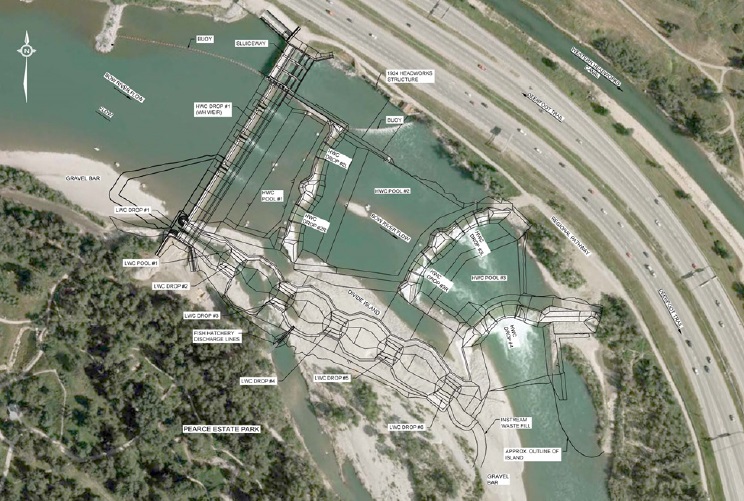
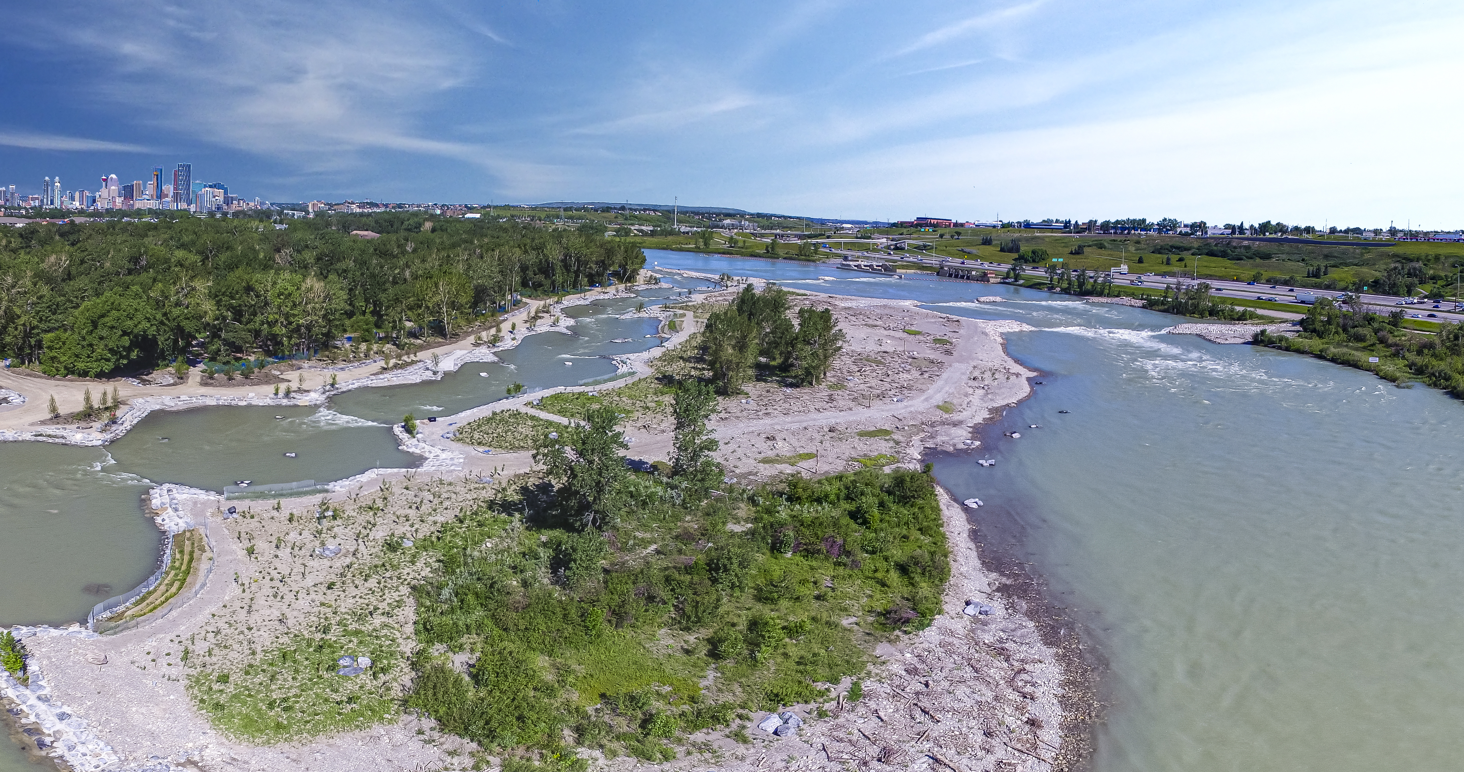
Sources:If you have ever been to Calgary, Alberta, you have likely seen the Harvie Passage on the Bow River. It was first built in 2011 but was damaged during the flood the city experienced in the summer of 2013. Now rebuilt, Harvie Passage is a wonderful landmark, tourist attraction and a popular recreational area. Here we share lessons learned and how the passage was rehabilitated and blended into the natural surroundings.
The Calgary Bow River Weir, originally constructed in 1908, is on the Bow River 3 km east of downtown Calgary. Prior to Harvie Passage being built in 2011, the weir was a barrier to boaters and fish passage for a 100 km section of the river. Harvie Passage was built to eliminate the extreme drowning hazard at the weir and to enable passage for boats and fish, while maintaining water diversions from the Bow River.
Harvie Passage was designed and constructed between 2006 and 2011 under the direction of Parks Foundation Calgary, The City of Calgary, Alberta Environment and Parks, and Alberta Transportation. Klohn Crippen Berger (KCB), in association with Northwest Hydraulic Consultants and Recreation Engineering and Planning, undertook the final design, contracting, construction contract administration and resident engineering, and post-construction monitoring of the project.
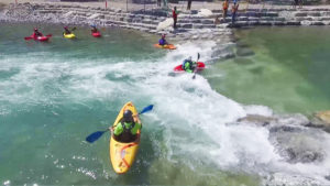
The project, completed on time and on budget, was named Harvie Passage in 2011 in recognition of significant funding from the Harvie family of Calgary. Harvie Passage proved to be a popular recreational boating destination and a place for picnickers, water, and wildlife enthusiasts.
The unprecedented flood in June 2013 of the Bow and Elbow Rivers resulted in a 1 in 100-year flood discharge and a large influx of sediment through Harvie Passage. The flood caused major infilling, damaged portions of the divide island, and eroded an old river channel. It also lowered downstream river levels, creating unsafe hydraulic conditions. Harvie Passage was closed from 2013 until its rehabilitation in 2018.
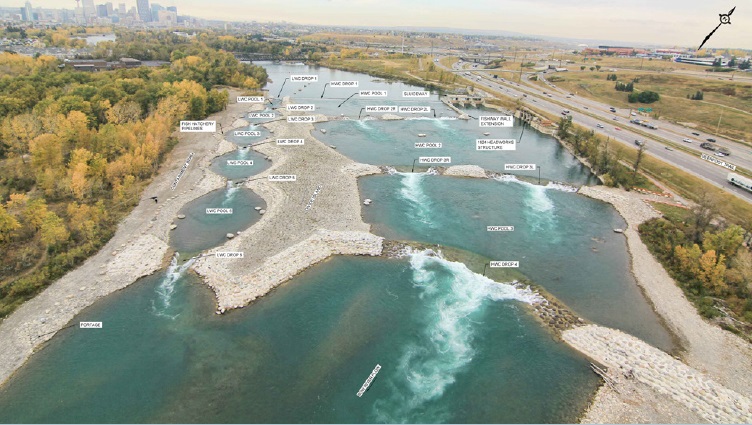
When Harvie Passage was completed in 2011, it was one of the largest facilities of its kind in North America, with very little precedent in Canada. How it would be used and valued was not fully understood. The project teams observed how the Passage performed, how it was used, and how the public accessed and valued it in the early years of its operation. Based on these observations, the following invaluable “lessons learned” were incorporated into the rehabilitation of Harvie Passage beginning in 2017:
Following the design approach of the original Harvie Passage, a key goal of the rehabilitation effort was to blend the works with the natural surroundings of the Bow River. This meant using natural construction materials where possible, such as boulders, cobbles, gravels, and riparian vegetation. (Conventional hydraulic designs normally consist of constructed materials, such as reinforced concrete, structural steel, and sheet piles.) To blend into the natural surroundings, erosion-prone areas were protected by placing large boulders and infilling the voids between boulders with fibre-reinforced concrete for structural integrity. The fibre-reinforced concrete prevents trapping people or animals between boulders and is safe for people to walk barefoot on.
KCB led the engineering consulting team listed below and was responsible for project management, design, environmental services, tendering, construction contract administration, and resident engineering:
Partnering with our client, Alberta Transportation, the owner, Alberta Environment and Parks, and the contractor, Bluebird Contracting Services - the project was completed on time and under the approved budget. The input, guidance and support of our partners are acknowledged and appreciated.
The rehabilitation of Harvie Passage resulted in a more robust and sustainable facility, with new terrestrial and aquatic habitats seamlessly integrated into the nearby Pearce Estate Park to create a unique recreational amenity for Calgarians and visitors to enjoy.
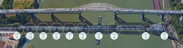
Canadian National Railway (CNR) operates a 110-year-old steel truss railway bridge which crosses the Fraser River, connecting the cities of New Westminster and Surrey, in the Metro Vancouver area in British Columbia, Canada. It is commonly known as the New Westminster Rail Bridge.
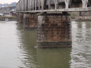
The main span of the bridge is supported by eleven piers made of unreinforced concrete, faced with granite blocks which support the superstructure truss spans. Pier 1 is on land (just off the photo in Figure 1), piers 2 to 5 are on deep concrete caissons, and piers 6 to 11 are on concrete-filled timber cribs with timber pile foundations installed by “jetting” into the river sands (Figure 2).
Although the bridge’s existing foundations have performed acceptably under static conditions for over 100 years, our analysis showed that the foundations would likely liquefy during a strong earthquake. This liquefaction, coupled with significant lateral spreading of the foundation soils over the river banks and along the riverbed, could result in excessive horizontal displacements of the piers, and structural failure of the bridge.
Replacing the bridge was not practical or cost-effective, so we developed a retrofit strategy to transfer the load of the bridge from the liquefiable foundation to a deeper non-liquefiable foundation, to withstand a 475-year return period earthquake. The most practical solution was to drive large diameter pipe piles upstream and downstream of piers 6 to 10, through the liquefiable layers to glacial till (Figure 3), and to connect the piles to the piers with steel collar frames.
We also considered methods to improve the strength of the potentially liquefiable foundation (i.e. ground improvement) around each of the piers and concluded that this was only practical at pier 11, where the ground surface is above river level. Ground improvement at piers 6 to 10 was not practical because of the required depth of pile driving, the large zone of riprap around the piers, and its impact on the environment and the river’s navigable channel.
Our solution meant that the existing foundations would continue to support the piers under static conditions, while the retrofitted piers 6 to 11 would limit the horizontal movements of the piers and bear the weight of the bridge during and after a strong earthquake.
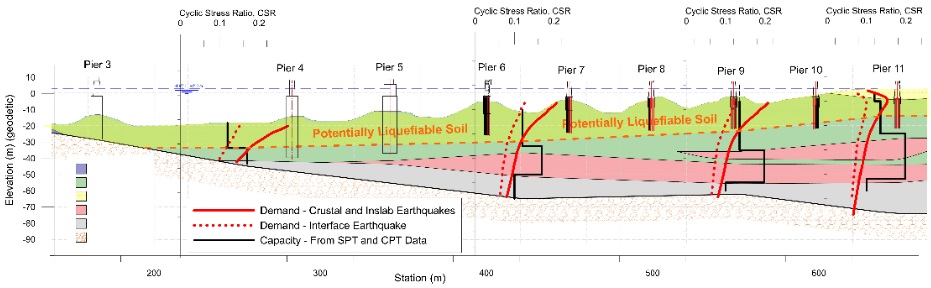
The foundation soils of the bridge consist predominantly of very dense glacial till overlain by clayey silt and river deposits. The river deposits are interbedded sands and silts of varying densities, identified as “potentially liquefiable soil” in Figure 3. The liquefaction assessment of the river deposits assumed a design earthquake with a 10% probability of exceedance in 50 years, i.e. a 475-year return period.
We used the finite difference program FLAC and effective stress-based constitutive model UBCSAND to evaluate the dynamic response of the bridge’s foundation soils and the retrofit piles (at the soil-pile interface) at piers 6-11. Results from the FLAC analysis showed the predicted maximum pile head displacements, during a strong earthquake, can be accommodated by replacing the existing bridge bearings with new sliding-plate bearings.
Construction is currently underway on the bridge’s seismic retrofit. The New Westminster Rail Bridge is a key transportation link in the gateway to Canada’s most important port in Vancouver. This work will dramatically improve the structure’s ability to withstand a major earthquake.
It has been just over 5 years since the Mount Polley tailings dam failure in British Columbia on August 5, 2014. However, variability in design and construction continues to challenge industry's efforts in managing tailings dam safety, as demonstrated by the two subsequent tailings dam failures (2015 and 2019) in Brazil. In this blog post, we will discuss what embankment dams are, what factors affect their safety, common failure causes of tailings dams, and what can be done to help safeguard them.
Embankment dams are a versatile type of dam that can be built on various soil and rock foundations. An embankment dam is an earth and/or rockfill retaining structure, including concrete-faced rockfill structures and tailings dams.
Unlike concrete dams, embankment dams can be built on foundation other than bedrock. However, due to diverse geological origins of the foundation, it is important to anticipate and correctly identify potential problems associated with this type of dam, including its foundation.
Tailings dams are a special type of embankment dam. While embankment dams are generally used to store water for water-supply, irrigation and hydropower, tailings dams are used to store mine tailings, fly ash or other industrial waste. The storage of mine tailings introduces a potential environmental degradation issue related to acid-generation and/or metal leaching geochemical reactions. McLeod and Murray (2003) discussed some of the differences relative to the design of water-retention and tailings dams.
The main natural hazards that affect the safety of an embankment dam are floods and earthquakes. These hydrological and seismic hazards must be carefully evaluated and designed against. Appropriate design criteria must be established which are compatible with the project site setting and severity of consequences of dam failure to the downstream communities and environment. Other hazards, such as fire (for coal waste), landslide, debris flow and avalanche, may also need to be assessed during site selection and facility design, operation and maintenance.
The design, construction and maintenance of a safe and properly functioning embankment dam requires an effectively implemented management system. The following human hazards and factors can undermine the safety of an embankment dam:
Embankment dams are vulnerable to the overtopping mode of failure. Once overtopped, an embankment dam is most often down cut by the erosion of released water, resulting in a dam breach and downstream flooding in rapid succession.
In 1994, the United States Committee on Large Dams (USCOLD) surveyed 185 cases of tailings dam failures and accidents. A dam failure is a breach of the dam structure resulting in the release of tailings; a dam accident refers to an event that did not result in the release of tailings. Klohn (1995) made the following observations of the USCOLD survey:
Similar survey results from the International Commission on Large Dams (ICOLD) review of 221 tailings dam incidents in 2001 corroborate the findings of USCOLD’s 1995 survey.
Besides running a normal and cost-effective dam operation, it is important for the operator to anticipate which component of the dam system could go wrong, what could be the potential consequences, and how to respond and minimize the consequences. Thus, it is critical to have a well-thought-out emergency response plan, detailing concrete actions to be taken by personnel at all levels, and having well-defined internal and external emergency communication protocols. Emergency response plans should also be continuously tested and improved.
Two recent developments occurred after the 2019 Brumadinho upstream tailings dam failure in Brazil:
All stakeholders, especially those who could be directly affected by a dam failure, should be aware of ongoing monitoring of dam performance, and be assured that design, operations and regulatory best practices are in place to reduce the risk to as low as possible. A higher level of governance, technical standards and regulatory consistency are required for protection of the public. Dam safety needs to have a much higher priority at all times so that it is prominent in the minds of all stakeholders over the long-term, even when other short-term urgent matters arise.
Klohn, E.J. 1995. Tailings Dams and Their Evolution to Major Hydraulic Structures and the Importance of Their Safety, Keynote Address to Canadian Dam Safety Conference, Banff, Alberta.
Lo, R.C. 2019. “Safeguard Embankment Dam Safety,” in Proceedings of the 87th Annual Meeting of International Commission on Large Dams (ICOLD), 9-14 June 2019. Ottawa, ON: Canadian Dam Association.
McLeod, H. and L. Murray. 2003. “Tailings Dam versus A Water Dam – What is the Design Difference?” in Proceedings of the 71st Annual Meeting of International Commission on Large Dams (ICOLD), 15 June 2003. Montreal, QC: Canadian Dam Association.
USCOLD 1994. Tailings Dam Incidents. United States Committee on Large Dams, 82 pps.
"The first rule of any technology used in a business is that automation applied to an efficient operation will magnify the efficiency. The second is that automation applied to an inefficient operation will magnify the inefficiency.” (Bill Gates)
The Fourth Industrial Revolution, which fuses the physical and digital worlds into “cyber-physical” systems, is underway. This revolution is influencing all disciplines and industries, including how the mining industry monitors their business assets including tailings dams. However, applying new technology to the surveillance of tailings dams, without critical thinking, can undermine its intended benefits or magnify an inefficient process.
What do we mean by tailings dam surveillance, and why is it important to understand how surveillance data are shared and manipulated before adding new technology to the process? "Surveillance" is an umbrella term that means different things to different people, and many people think of technology first when planning surveillance programs. An effective tailings dam surveillance program must have specified objectives and must identify and manage selected parameters that can be monitored and will add value by minimizing risk.
Designing a tailings dam surveillance program is often done without first critically thinking about its objectives or the appropriate input data and may be biased by the desire to implement leading-edge technology. A practical way to design and manage a tailings dam surveillance program is to adopt the Plan-Do-Check-Act cycle used in business for the control and continuous improvement of processes or products (i.e. the basis of quality management systems).
Here are key questions to ask using the Plan-Do-Check-Act cycle when reviewing an existing tailings dam surveillance program or designing a new one.

PLAN
Here are a few examples of tailings dam and other engineering project surveillance programs that have successfully integrated technology.
Closed Tailings Dam
This closed tailings dam, located in remote northern British Columbia, Canada is in active care. It has ten Global Navigation Satellite System (GNSS) receivers, six prisms, a weather station, ten piezometers, five digital cameras, and two pond water level stations. The system is powered by solar panels and heavy-duty battery units. Data loggers and radio monitoring stations are linked to a Trimble T4D System. Operations, Maintenance and Surveillance Manual (OMS) threshold exceedances are sent via e-mail / text message alerts for action. (Source: Newmont Goldcorp)
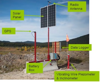


Photos: Newmont Goldcorp
Active Tailings DamThe tailings dam surveillance program at the Quellaveco copper mine in Peru is part of Anglo American’s FutureSmart MiningTM program. The surveillance program includes collecting information on the amount of water in its tailings dams, and real-time strain, deformation and seepage data via fibre-optic cable. The system also includes micro-seismic monitoring of tailings dam foundations, which checks on geological and structural features in the dams and their foundations. (Source: Mining Weekly)
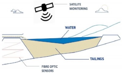 Photo: Anglo American
Water Supply Dam
Cleveland Dam in North Vancouver, B.C., Canada is classified as an extreme consequence dam. The dam’s safety surveillance program includes a complex network of remotely monitored instrumentation, including piezometers, inclinometers, turbidity and flow sensors, extensometers, strain gauges and pressure transducers. Continuous monitoring is integrated with a Supervisory Control and Data Acquisition (SCADA) System, Corporate Data Historian, and the water supply system control room which operates around the clock. Automated e-mail alerts and a call-out tree is triggered (including to a downstream fish hatchery) if critical thresholds are exceeded, and an appropriate response plan is activated. (Source: Metro Vancouver)
Photo: Metro Vancouver
For further information about this topic and how we can help you, please contact us at info@klohn.com or call any of our global offices.